
MONTHLY ENGINEERING PROGRESS REPORTS
Lumpkin Road Drainage and Mobility Improvements
Construction Documents
The project involves the reconstruction of Lumpkin Road between IH-10 and Northbrook Road. The primary purpose of the project was to reconstruct the roadway to meet current geometrics requirements due to safety considerations, provide pedestrian access to Houston Community College, improve traffic operations, and improve drainage deficiencies along with the replacement of the aging public utilities. The section extending north from Westview Drive to Northbrook Drive was added to address drainage issues developed from converting the roadway to curb and gutter and other deficiencies along the project limits.
Improvements included widening Lumpkin from a 2-lane asphalt open ditch section to a 40-ft concrete curb and gutter section with one-lane in each direction and a center two-way-left-turn-lane. City of Houston and TIRZ 17 partnered to improve the Westview Detention Basin to assist the project in meeting City of Houston drainage criteria and extend the storage benefit to the adjacent community. Westview Detention basin was deepened and vertical walls were installed to provide the most benefit to Lumpkin Road and surrounding areas. This project added an additional 20 acre-feet of detention capacity. Thus, mitigation for Lumpkin Road was a combination of both detention and conveyance improvements. The project also involved the relocation of large diameter water lines to accommodate the addition of large storm boxes. Right-of way acquisition and Landscape amenities were also part of the project.
- Contractors Notice to Proceed document
- Traffic control plan
- Architectural landscape renderings
- Westview to Northbrook landscape site plan
- Progress Photo 1
- Progress Photo 2
- Presentation to the Board September 24, 2013
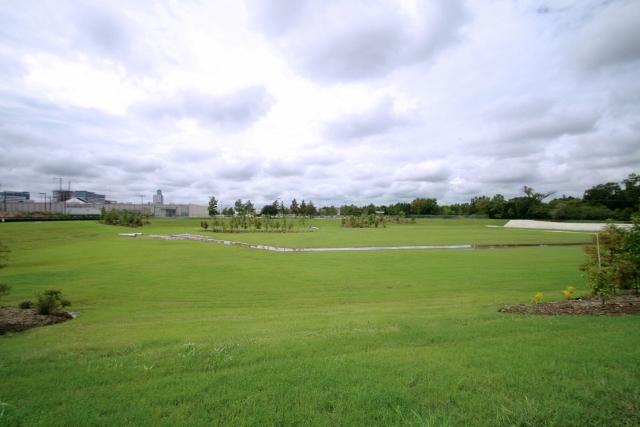
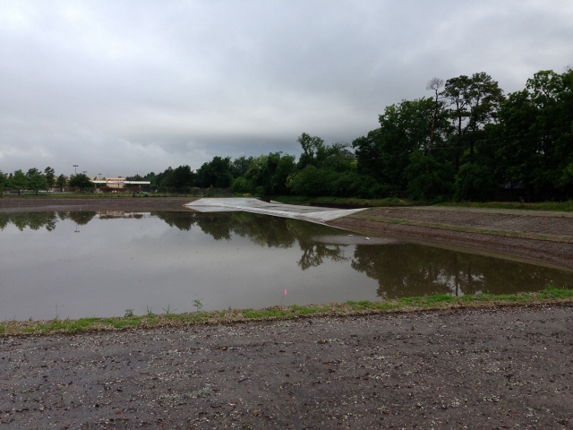
LUMPKIN ROAD DRAINAGE AND MOBILITY IMPROVEMENTS IN PROGRESS
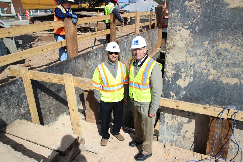
Left to right; LAN Project Manager, Muhammad Ali, P.E., and TIRZ 17 Executive Director, Don Huml during recent site inspection.
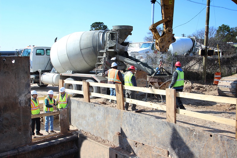
Placing concrete for large storm water junction box under the intersection of Westview and Lumpkin.
Town and Country West Drainage and Mobility Improvements
Status - Detailed Design Phase
Construction Cost: $10 million, 2,700 LF, Status: Detail Design stage
A preliminary engineering study for the extension of Town & Country Way was conducted to provide connectivity to the Beltway 8 Frontage Road and the construction of a single lane roundabout at the intersection of Town and Country Way and Town and Country Boulevard. Benefits of the extension included improving traffic circulation in the immediate area by completing the street grid network. It also creates an alternate route for the IH-10/Beltway 8 interchange which is prone to flooding and can also accommodate emergency vehicles when this condition occurs. The roundabout has many benefits like safety, efficiency, provides fewer opportunities for collisions and will help align the 75-foot offset in northbound and southbound approaches of Town and Country Boulevard.
The project will significantly improve drainage, mobility, safety and access management. By maximizing the sub-surface detention the proposed Town & Country drainage system will meet City of Houston’s criteria and reduce flooding. The proposed improvements will provide approximately 8 acre-feet of detention. The aging public utilities will also be upgraded within the project limits
North Gessner Drainage and Mobility Improvements, Phase I
North Gessner Drainage & Mobility Improvements - IH10 (Katy Frwy) to Westview (TIRZ 17 CIP No. T-1732A) - Drainage and mobility improvements are proposed along North Gessner Road from IH 10 (Katy Freeway) to the north side of the Westview Drive intersection. The proposed improvements are based on the recommendations in the Preliminary Engineering Report (PER) (LAN - August 2013), the Preliminary Plans (LAN – October 2012), and the TIRZ 17 Regional Drainage Study. The current efforts include the project Drainage Impact Analysis and Report as well as development of constructions plans.
Briar Branch Channel Improvements (Unit W140-01-00)
The proposed W140-01-00 channel improvements project is the second phase of the Briar Branch regional drainage solution that will benefit the immediate area. It will lower the water surface in Briar Branch to relieve the storm sewer systems contributing to the channel. The third and final phase involves storm sewer improvements that drain to the proposed improved channel. Attached are copies of the Preliminary Engineering Report and Impact Analysis. The project is currently in the detailed design phase.
Preliminary Engineering Report (September 16, 2013) (166 MB),
Impact Analysis Report(December 31, 2013) (89 MB) Letter of No Objection (January 15, 2014)
Briar Branch Channel Lateral Storm Water Improvements (aka Straws)
Briar Branch (W140-01-00) Related Flood Mitigation & Bunker Hill Bridge Study (TIRZ 17 CIP No. T-1734B) - The Briar Branch flood mitigation effort is proposed for 5 locations that contribute flow to Briar Branch in between Gessner Road and the Briar Branch Detention Pond. Current efforts include preliminary engineering and design services for flood mitigation of five “straws” along Briar Branch (HCFCD Unit W140-01-00) from the east side of Gessner Road, east to Oak Tree Drive and the east side of the TIRZ 17 Briar Branch Detention Basin. The current project also includes a feasibility study of the need to modify the Bunker Hill Bridge located at the intersection Bunker Hill Road and Briar Branch. The proposed improvements are based on the recommendations of the Preliminary Engineering Report (PER) (LAN – Sept. 2013).
Memorial Drive Drainage and Mobility Improvements
Drainage Impact Analysis Report dtd October 2020
Preliminary Engineering Report (73,341 KB)
Environmental Site Assessment II Report
Environmental Site Assessment II Report - Additional
Phase 1 Geologic Fault Review from east of BW8 to east of Tallowood Rd
Construction Cost: $12 million, 4700 LF, Status: Preliminary Engineering stage
A preliminary engineering study is being prepared to evaluate the Memorial Drive alignment from Beltway 8 northbound frontage road to just east of Tallowood Rd. The Memorial Drive project will provide drainage improvements, and increase mobility, safety, and access management. The drainage goal of the project is to improve the conveyance system to meet City of Houston criteria for the 2-year and 100-year storm events, and to oversize the storm sewer system to provide additional benefit for the adjacent community. The proposed drainage improvements will provide approximately 7 acre-feet of subsurface detention. The existing pavement is in poor condition and the roadway does not meet current City of Houston geometric requirements. The existing roadway will be improved to a curb and gutter concrete pavement section with continuous ADA compliant sidewalks and wheel chair ramps, and will be reconstructed to meet current City of Houston criteria. The aging public utilities will also be upgraded within the project limits.
W140 Detention Basin
Presentation (February 28,2012) (726 KB)
W140 Impact Analysis (April 29, 2013) (78 MB) Presentation to the Board (June 25, 2013)
Spring Branch West Super Neighborhood Presentation 11/13/14 Download
The W140-01-00 (Briar Branch) Detention Basin will provide significant flood damage protection for the communities adjacent to and draining to Briar Branch. The detention basin is designed to provide flood damage protection as an independent and stand alone project, and to maximize the benefit of other planned improvements within the Briar Branch drainage area. Preliminary engineering efforts for the W-140-01-00 Detention Basin are nearing completion.
Barryknoll Lane - W151 to Bunker Hill
Preliiminary Engineering Report (April 11, 2012) (122 MB)
The purpose of the Barryknoll Lane Improvement project is to improve local and regional drainage with the installation of additional storm sewer which will result in increased conveyance and storage. The Barryknoll storm sewer was classified as inadequately sized in the City of Houston Comprehensive Drainage Plan and has been identified as a key improvement component in the HCFCD W151 Feasibility Study. The project was adopted by the Tax Increment Reinvestment Zone No. 17 as part of their Drainage Action Plan and is part of the current five year CIP.
TIRZ 17 Regional Drainage Study
Regional Drainage Study Presentation (June 29, 2011) (3 MB)
Final TIRZ 17 Regional Drainage Study Report Text (February 28, 2012) (737 KB)
Report Exhibits (February 28, 2012) (40 MB)
HCFCD W151 Implementation Study Report is available at http://www.hcfcd.org/dl_reports.html under “W151 Implementation Study Final Report.”
The goal of TIRZ 17 Regional Drainage Study is to identify individual drainage improvement projects that function collectively to benefit the region as well as independently to account for project sequencing. Recommended drainage improvement projects will be designed to cost effectively reduce structural and nuisance flooding. Improvement alternatives will be developed for various levels of protection, and a cost benefit analysis will be provided to assist in determining the most cost-effective solution. Recommended improvement projects will be prioritized with an objective ranking matrix that will include a list of projects that may be constructed quickly to provide drainage relief to poorly drained areas in a timely manner.
The TIRZ 17 Regional Drainage Study will build on the Harris County Flood Control (HCFCD) W151-00-00 Implementation Study from Buffalo Bayou to IH-10 completed August 6, 2009. This study will not seek to duplicate the HCFCD model effort, but build upon it to create a more detailed and inclusive model of the W151 watershed including the area north of IH-10.
Memorial Drainage and Mobility Study from Beltway 8 to West Bough
Memorial Mobility Study (85 KB) | Memorial Drainage PER (35 KB)
Lockwood, Andrews & Newnam, Inc. (LAN) was contracted by Tax Increment Reinvestment Zone No. 17 (TIRZ 17) to perform a Drainage and mobility study on Memorial Drive between Beltway 8 Northbound Service Road (NSR) and West Bough Lane in Houston, Texas. For the mobility study, LAN has was tasked with analyzing the intersections and investigating left-turn lane alternatives aimed at improving operations. LAN recommends that two eastbound left-turn lanes be constructed on Memorial Drive. This recommendation is based on intersection capacity utilization (ICU) level of service (LOS) as well as potential safety benefits. Left-turn lanes have been shown to minimize turn-related crashes and minimize delay to through traffic. For the Drainage PER, LAN was tasked with evaluating the Memorial and West Bough storm sewer system.
Gessner Road Improvements
Project Location Map (856 KB) | Schedule (530 KB) | Fast Facts | Press Release
Gessner Landscaping Plan.pdf (8 MB)
Improvements to Gessner Road are currently being designed to widen the roadway from a six-lane divided, curb-and-gutter boulevard to an eight-lane divided, curb-and-gutter boulevard from Barryknoll Lane to IH-10. The project is a joint effort between the TIRZ 17 Redevelopment Authority and the Texas Department of Transportation. The design will include enhancements to the landscaping, sidewalks, signage, and other areas.
Bunker Hill Road Improvements
Project Location Map (797 KB) | Schedule (580 KB)
Construction Documents (12 MB)
Final Phase I ESA - Report & Figures 1-3.pdf (4.5 MB)
Final Phase I ESA - Appendix A.pdf (3 MB)
Final Phase I ESA - Appendices B-E.pdf (9.6 MB) | Final Phase II ESA.pdf (36 MB)
Final Geotechnical Report.pdf (148 KB)
Final Geotechnical Supplemental Letter.pdf (2 MB) | Final Fault Study.pdf (4 MB)
Bunker Hill Landscaping Plan.pdf (4 MB)
Bunker Hill Technical Memo (1 MB)
Bunker Hill Road will be widened from IH-10 to Long Point Road and some existing utilities will be improved. The design calls for a four-lane boulevard section from IH‑10 to the Briar Branch. The road will then transition to a three-lane section (includes a center turn lane) north of Briar Branch to Long Point Road. Also, the intersections at Long Point Road and Westview Road will be improved, including the addition of a traffic signal at Westview Road. Localized flooding will also be addressed by increasing the storm sewer capacity along portions of Bunker Hill Road. This project is a joint effort between the TIRZ 17 Redevelopment Authority and the City of Houston.
Kimberley Road Improvements
Summary (2.2 MB) | Table of Contents (1 MB) | Executive Summary (3.7 MB)
Introduction (6.4 MB) | Drainage Analysis (4 MB) | Roadway Assessment (2 MB)
Utility Assessment (1 MB) | Conclusion (354 KB) | Appendix A (2 MB)
Appendix B (10 MB) | Appendix C (20.5 MB) | Appendix D (6.6 MB) | Appendix E (1.2 MB) |
Appendix F (26 MB) | Appendix G (6.6 MB) | Appendix H (13 MB)
Work consisted primarily of drainage improvements, sanitary sewer rehabilitation, new water line, roadway reconstruction, new traffic signal system, and landscape improvements along Kimberley Lane from Beltway 8 to West Bough Lane. Drainage improvements included upsizing of the storm sewer and raising road height at the Town & Country intersection. The work was substantially completed October of 2011.
Kingsride Lane Traffic Flow Improvements
Project Location Map (797 KB) | Exhibit (530 KB) | Schedule (530 KB)
Construction Documents (1.3 MB)
This project will add a 300-foot long eastbound turn lane on Kingsride Lane at Gessner Road. Initially, the added lane will function as a right turn lane. Ultimately, with the extension of Kingsride further east, the eastbound approach would be reconfigured to provide additional capacity for left turns. A traffic signal will also be added at the intersection of Frostwood Drive and Kingsride Lane.
Queensbury Lane Storm Sewer Improvements
Project Location Map (800 KB) | Schedule (530 KB)
Queensbury Storm Sewer Improvement Preliminary Engineering Report (27MB)
Construction Documents (836 KB)
The project will replace approximately 685 feet of storm sewer with a box culvert along Queensbury Lane between Town and Country Boulevard and the Sam Houston Tollway Frontage Road. The objective of this project is to bring the storm sewer along Queensbury Lane into compliance with City of Houston Drainage Criteria.
Briar Branch Drainage Study
Project Location Map (530 KB) | Drainage Problems Survey Results (976 KB)
Briar Branch Drainage Study.pdf (38MB)
Briar Branch was previously studied east of Blalock Road as part of the Tropical Storm Allison Recovery Project (TSARP). This study extended the limits of the TSARP floodplain analysis along Briar Branch west of Blalock Road and identified the existing level of service provided by the channel. The project limits began at Gessner Road and extended east to Blalock Road. The TIRZ 17 Drainage Action Plan identified Briar Branch as the only unstudied channel of the four open channels that serve TIRZ 17 as storm sewer outfalls. In response to the Drainage Action Plan, TIRZ 17 Redevelopment Authority authorized this study of Briar Branch, also known as Harris County Flood Control District (HCFCD) Unit No. W140‑01‑00.
Drainage Action Plan
Drainage Action Plan Report (5 MB)
TIRZ 17 Redevelopment Authority commissioned the development of a TIRZ specific Drainage Action Plan to assist the Authority board members in understanding the area drainage status, identifying problem locations within the system, and prioritizing proposed projects that impact area drainage. A prioritized recommended project list was provided. In general terms, the anticipated benefit for each recommended improvement was quantified and used in conjunction with planning level cost estimates to prioritize the potential projects. The Drainage Action Plan is intended to define future drainage projects with the intent of improving areas with undesirable drainage conditions located within TIRZ 17.
East-West Mobility Improvement Study
Download Draft (3.05 MB)
This study analyzed geometric and traffic operations of several roads currently providing east-west circulation in the vicinity of the TIRZ 17 area of Houston. The purpose of the study was two-fold. The first purpose was to analyze the incremental costs and benefits of three road improvement projects in the adopted TIRZ 17 Transportation Improvement Plan. These improvements were: the extension of Kingsride Lane from Gessner Road to Barryknoll Drive, the completion of Town & Country Way from the Beltway 8 northbound frontage road to Gessner Road, and the construction of Claret Lane from the Beltway 8 northbound frontage road to Bunker Hill Road. The second intent of the study was to examine other, easily implemented projects that could be accomplished to help improve east-west mobility within TIRZ 17. A traffic operational analysis was conducted within the study area for the Year 2015, assessing the implications of building each of the three improvements identified above under various conditions.
TIRZ 17 Drainage Study - 2002
Download Drainage Study (45 MB)
This study evaluates the existing storm drainage capacity within the TIRZ 17 district to determine potential storm sewer infrastructure improvements that would provide improved drainage under existing and future conditions. The study was based on previous study information and supplemented with new modeling as needed. The goal of the study is to develop ideas for potential improvements to improve drainage in the district and surrounding areas.